Menu

Tips to Withstand Hot Summer Days/Nights

We’ve finally reached the true dog days of summer for the Outer Banks. The hotter and more humid days of the year. Listed here are a few tips to inform you on how to stay cool during these sensuous days of summer.


Bring lots of water:  Pack a cooler full of ice and bottled water and just keep drinking.  Please stay hydrated!  You can also bring hydrated snacks like watermelon, cucumber and other fruits to help you stay cool.  Stay away from sugary drinks such as sodas; they decrease the ability of your body to store water.  Also be careful while drinking alcoholic drinks.  Be sure to drink water in-between.

Take a dip to cool off

Take a dip:  While at the beach or by the sound, grab a spot close to the edge so you can take a quick dip without being too far from your stuff.  You can even place your chair in the water just so you can keep your feet wet.

cloudy weather

Look for clouds:  During cloudy days the weather is a little bit more forgiving.

beach umbrella for sun protection

Seek shade:  Umbrellas and canopies provide some much needed relief when you need a break from the sun.  You can also find some shade underneath the fishing piers.  Outer Banks Fishing Piers

How to apply sunscreen

Wear sunscreen:  Sunscreen doesn’t have a cooling effect but its protective effect is crucial during summer weather.  Sunburn can cause a fever and various signs of dehydration.  At the minimum, use SPF 15 or a better option of SPF 30. Reapply often!  Every two hours is ideal, or more often while swimming.

picnic on the beach

Make food without using the oven or stove:  Find foods that don’t need to be cooked, or don’t need heat to be cooked.  If you are cooking, keep the cool air in and the temperature down by using the microwave instead of the stove or oven.  Cool soups are great in warm weather.  As well as popsicles, slushies, frozen fruit, and other frozen treats to help you stay cooled down.

Use a fan to stay cool while you sleep


Stay cool while sleeping:  Lightweight cotton sheets are breathable and good for promoting ventilation and airflow. Wearing cotton clothes while sleeping is also recommended. Get a jump start on hydration by drinking a glass of water before bed.


FAQs about the OBX

Frequently Asked Questions
ABOUT THE OBX

We asked our staff here at Stan White Realty & Construction what were some of the most commonly asked questions they are being asked while they help you plan your Outer Banks vacation.

Please feel free to call one of our reservationist if you have any other questions we didn’t answer in this blog post.

We would be more than happy to help!

#1-800-338-3233 or email us at info@outerbanksrentals.com

Q: What is the difference in all of the various home locations?

A: We have properties located in all different areas of the islands all the way from the towns Corolla to South Nags Head.

Location Descriptions

Q: How do I get to your offices?

A: We have three office locations

Corolla Office
812 Ocean Trail
Corolla, NC 27927
#1-800-753-6200

Duck Office
1232 Duck Road
Duck, NC 27949
1-800-992-2976

Nags Head Office
2506 S. Croatan Hwy
Nags Head, NC 27959
1-800-338-3233

Stan White Realty Offices

Q: Do I need a fishing license to fish?

A: A Coastal recreational Fishing License is required on the Outer Banks. Children under 16 are exempt. An individual doesn’t need a license for charter boat and pier fishing. Both are covered by a blanket license.

Q: Where can I buy a fishing license?

A: At a local bait and tackle shop and at any of the piers.

TW’s Bait & Tackle
Stop N Shop – fising tackle
Nags Head Fishing Pier
Jennette’s Pier

Q: Are fires allowed on the beach?

A: Corolla, Duck, Southern Shores, Kitty Hawk and Kill Devil Hills – No

Nags Head and South Nags Head – yes with a permit.

Beach Pit Fire Information

Q: Should I worry about traffic traveling to the OBX?

A: Yes. When traveling to the OBX in the summer season (June through August) plan ahead for traffic delays across the Wright Memorial Bridge and Highway 12 north through Duck during the early morning and afternoon on the weekends. To avoid this traffic take alternate routes like Highway 64 over Roanoke Island. Or try arriving earlier in the day or late evening.

Q: What are the leash laws for dogs?

A: Corolla and Duck is all year round with a leash. Southern Shores is before 9a.m. and after 6p.m. Kill Devil Hills and Kitty Hawk are with a leash. Nags Head is year round with a leash.

Q: Where can I launch my personal boat on the OBX?

A: Kitty Hawk – Kitty Hawk Boat Ramp and Hand Launch

West Kitty Hawk Road and Bob Perry Road
Kitty Hawk, NC 27949

Q: What does express check-in involve?

A: During the summer at the Nags Head office our staff provides Express Check-in. This is set up in the parking lot and allows guests to quickly and easily drive thru the outdoor check-in without having the leave their car. The purpose of Express Check-in is to shorten the check-in process and get you to your OBX rental home and on vacation sooner.

Express Check-in

Q: Do you offer travel insurance on my vacation?

A: We do offer travel insurance through an outside company, Red Sky Travel Insurance. We encourage all of our guests to purchase the Travel Interruption Insurance with their Outer Banks vacation rental by including this policy with your reservation. To purchase the policy, initial in the space reservation on your lease agreement. To decline just leave the space blank and it will be deducted from your total.

Red Sky Travel Insurance

Q: Where can I go in case of an emergency?

A: Need care and relief for a minor injury, ache or pain during your stay on the Outer Banks? Or maybe even your pet needs some emergency care. Here is a list of urgent care centers.

Sentara Urgent Care
The Outer Banks Hospital Urgent Care Center

For your furry friends:

Martin’s Point Veterinarian Hospital
Animal Hospital of Nags Head
Coastal Animal Hospital

Outer Banks History

Outer Banks Historical Sites

The Outer Banks of North Carolina has so much more to offer than just a pretty picture. There is more to these barrier islands than meets the eye. From Corolla to Ocracoke visitors of the OBX can find something knowledgeable and appealing.  Historical landmarks are scattered all along the Outer Banks varying from brick lighthouses to giant sand dunes. Be sure to check out each of these sites during your vacation to the OBX this year.

Currituck Beach Lighthouse

The Currituck Beach Lighthouse was the last major brick lighthouse built on the Outer Banks. It stands 158 feet tall and is made of red-brick. The lighthouse towers above the northern Outer Banks landscape in the historic Corolla Village. Visitors can climb the winding staircase of 220 steps to the top for a panoramic view of Currituck Sound, the Atlantic Ocean and the Currituck Outer Banks. The Currituck Beach Light Station still serves as an aid to navigation. The beacon comes on automatically every evening at dusk and ceases at dawn.

Location: 1101 Corolla Village Road, Corolla, NC 27927

Wright Brothers National Memorial

This memorial marks the site of the world’s first powered flight on December 17th, 1903. The visitor’s center features full-scale reproductions of the Wright 1903 Powered Flyer and interpretive presentations. The grounds feature historical markers of each attempted powered flight, a replica camp buildings and a 60-foot granite monument on top of a 90-foot dune honoring the Wright Brothers.

Location: N Croatan Hwy, Kill Devil Hills, NC 27948

Jockey’s Ridge State Park

The largest natural living sand dune on the East Coast. The park is 426-acre park is a leading location for kite flying, hiking, and sightseeing and sunsets, with a view arching from the ocean to Roanoke Sound. It also includes a visitor center with a museum and a 360-foot boardwalk with exhibits that explain the dune’s ecology.

Location: 300 W. Carolista Drive, Nags Head, NC 27959

Graveyard of the Atlantic

The Graveyard of the Atlantic is a region of the ocean just offshore of the Outer Banks where some 3,000 shipwrecks decorate the depths from Kitty Hawk south to Ocracoke. Shipwrecks have happened all along this region of North Carolinas coast due to its deceptive shoals, underwater sandbars and the powerful storms that have come along. Today you can see some of these wrecks from shore or by snorkeling or scuba diving. The Graveyard of the Atlantic Museum is a public, non-profit, educational institution. The museum is dedicated to the preservation and presentation of the shipwrecks of the North Carolina Outer Banks from the earliest periods of exploration.

Location: 59200 Museum Dr, Hatteras, NC 27943

Roanoke Marshes Lighthouse

The Roanoke Marshes Lighthouse is tucked away at the quiet east end of the Manteo Waterfront. This is one of the most overlooked of the Outer Banks lighthouses because of its small stature and limited visibility. Visitors to historic Downtown Manteo will have no problem spotting the small lighthouse which stretches out 40 yards into the Roanoke Sound. This lighthouse has a white exterior with black shutters and red shingled roof with a wooden boardwalk with a waterfront view.

Location: Manteo Waterfront, Manteo, Roanoke Island, NC 27954

The Lost Colony of Roanoke

The village of Roanoke was one of the first English colonies to be established on the soil. The colony was recruited by Sir Walter Raleigh. The Governor, John White, traveled back to England to later return with supplies the colonist requested. Three long years later John White returned to find the area that was once a village was stripped of its people. What was left behind were some small cannons, an opened chest, a tall fence built around the perimeter of the former village site, and a single word carved on a fence post, “Croatoan” and the letters “CRO” carved into a nearby tree. Their fate then subjected to many theories and controversies. Their story is reenacted every summer during performances of The Lost Colony, the nation’s longest symphonic drama in Fort Raleigh’s Waterside Theatre in Manteo.

Location: 1409 National Park Dr. Manteo, NC 27954

The Elizabethan Gardens

The Elizabethan Gardens is a 10.5 acre public garden located within Fort Raleigh National Historic Site. The Gardens contain over 500 different species of plants. Flower displays are changed seasonally to insure colorful displays throughout the year. Elaborate gardens were kept to entertain Queen Elizabeth I during her region. The Elizabethan Gardens was created for visitor’s enjoyment, and as a living memorial to the time when Sir Walter Raleigh’s lost colonists lived in this very place over 400 years ago.

Location: 1411 National Park Drive, Manteo, NC 27954

Fort Raleigh

The Fort Raleigh National Historic Site sits on 513 acres on the north end of Roanoke Island just three miles from the historic town of Manteo. It was established in 1941. The park honors the first English attempts to colonize the New World from 1585 to 1587. Today the park is home to a visitor’s center, museum, Elizabethan Gardens, The Lost Colony outdoor drama, historic tour trail, gift shop, and picnic area. Fort Raleigh National Historic Site preserves the cultural heritage of the Native Americans, European Americans and Africa Americans who have lived on Roanoke Island.

Location: 1401 National Park Dr, Manteo, NC 27954

Bodie Island Lighthouse

Visitor’s traveling towards Hatteras Island can’t help but notice the black and white horizontal striped structure peaking over the trees on the soundside. The lighthouse is 156 feet and has 214 steps to the top. The Currituck Beach Lighthouse is considered its architectural twin. The Bodie Island Light Station is located at the northern end of Cape Hatteras National Seashore.

Location: 8210 Bodie Island Lighthouse Road, Nags Head, NC 27959

Cape Hatteras Lighthouse and Museum

The Cape Hatteras Lighthouse is the tallest in the United States standing at 208 feet. This lighthouse is painted in black and white spirals with a red base. It is one of the most famous and most recognizable lighthouses in the world. Cape Hatteras Lighthouse protects one of the most treacherous stretches of the Outer Banks, with a beam of light that spans 20 miles out to sea. Considered one of Hatteras Island’s biggest attractions. Come and climb the 257 steps to find the most rewarding panoramic view of Hatteras Island from Avon to Hatteras Village.

Location: 46379 Lighthouse Road, Buxton, North Carolina 27920

Ocracoke Lighthouse

The Ocracoke Lighthouse is North Carolinas oldest operating lighthouse. And the second oldest in the United States. The lighthouse only stands at 65 feet tall and is the smallest lighthouse on the Outer Banks. The lighthouse still towers over the 4 square miles of Ocracoke Village. Its light can be spotted up to 14 miles into the Pamlico Sound and the Atlantic Ocean.

Location: Lighthouse Road, Ocracoke, NC 27960

Outer Banks National Scenic Byway

Outer Banks National Scenic Byway

Take the road less traveled. Take the time to experience the actuality of North Carolinas Easternmost parts along the coast of the state’s barrier islands. Currently the Outer Banks National Scenic Byway is made up of nine barrier islands – or banks. The islands protect the mainland coast from the Atlantic Ocean’s, at times, compelling winds and water.

The length of the secluded road is 142.5 driving miles.

The driving time is 6.5 hours – including 3.5 hours on two ferries.

The byway begins in the Outer Banks region and ends in the Crystal Coast region. The Outer Banks National Scenic Byway passes through one of the nation’s great coastal landscapes, tidal marshes, wind-swept dunes, and alluring sounds border the roadway. The byway also includes two national seashores, Cape Hatteras and Cape Lookout. There is two national wildlife refuges – Pea Island and Cedar Island. The barrier islands are separated away from the mainland by six different sounds ranging from three to 40 miles wide. From North to South they are: Currituck, Albemarle, Roanoke, Pamlico, Core and Bogue.


The oceangoing culture of the 21 coastal villages along the road is what makes this route so unique. Each maritime village shares a common cultural heritage which is shaped by the well know barrier islands and three shallow sounds – Pamlico, Core and Back. During the drive visitors will notice that the tiny villages are held together by locally owned businesses with barley a chain business in sight.   The residents of these villages build boats, fish and hunt, operate ferries, guard the coast, tell stories and provide services to visitors. Fishing and hunting as livelihoods are keys to this culture that goes along with living on the coastal edge. Byway villages are held to a significant national history, a collection of the nation’s earliest civil works. This includes four historic lighthouses and eight early U.S. Life-Saving Service or U.S. Coast Guard stations. The four lighthouses along the byway are Bodie Island Lighthouse, Cape Hatteras Lighthouse, Ocracoke Village Lighthouse, and Cape Lookout National Seashore Lighthouse.

Take the drive on The Outer Banks National Scenic Byway and get a feel for how life was like before the hectic schedules and tourist-driven cities. The Outer Banks National Scenic Byway begins in the north at Whalebone Junction. The joining of US 64-264, US 158, and NC 12 in Nags Head, Dare County, North Carolina. Travelers following the Byway’s NC 12 south can see the Atlantic Ocean on the east and the Pamlico Sound on the west. The road crosses over Bodie and Hatteras islands in Dare County, Ocracoke Island in Hyde County and Down East in Carteret County to end on the west side of North River at the intersection of US 70 and Merrimon Road. The byway includes two ferry rides. One free, between Hatteras and Ocracoke Islands. The other, between Ocracoke Island and Downs Easts Cedar Island. The Scenic Byway ends in Beaufort in the Down East region of North Carolina.

http://www.visitnc.com/trip-idea/outer-banks-national-scenic-byway-1

http://gardenandgun.com/blog/back-road-trip-outer-banks-scenic-byway

New findings on The Roanoke Island Missing Colony

New findings on The Roanoke Island Missing Colony

One of the first few thoughts that come to mind when you think of the Outer Banks includes Roanoke Islands Lost Colony. Chances are if you have ever visited Manteo or the OBX in general, then you have seen the outdoor drama The Lost Colony produced by the Roanoke Island Historical Association. This is a non-profit association created to help celebrate the history of the first English colonies on Roanoke Island, North Carolina. The play is was generated to honor the founders of The Lost Colony through drama, education, and literature.

For those of you that don’t know the story about the disappearance of The Lost Colony, let’s bring you back to the 16th-century. In July of 1587, 117 English men, women, and children came ashore on Roanoke Island with a commission from Elizabeth I to establish a permanent English settlement in the New World. An Englishmen named John White helped lead the settlers to Roanoke Island, which is located inside the chain of barrier islands that is today called the Outer Banks. It was Sir Walter Raleigh’s second attempt to colonize North Carolina, but the first to include civilians and families. White’s granddaughter, Virginia Dare was the first child born in the New World to English parents just weeks after their arrival. A resupply trip sent White back to England that same year. A naval war with Spain delayed his return. Three years later in 1590, when English ships returned to bring back supplies, the settlers had vanished. The only clue left behind was the word “Croatoan” carved into a fence post, and the letters “CRO” on a tree. Many believe these referred to what is now Hatteras Island, 50 miles south of their settlement.

On and off for the past three years, Nicholas M. Luccketti and his archaeology team have been working along the coast of the Albemarle Sound trying to uncover more clues on this mystery. Mr. Luccketti and colleagues with the First Colony Foundation have been digging up parts of the shores and hillsides of the Albemarle Sound hoping to find traces of the colonists. The dig site where they have been working is located in a secluded cove off of a creek in Merry Hill N.C., they call the spot Site X. The archaeologists have not found evidence of structures there, but have found ceramics and other material of European origin that might have come from Roanoke colonists. In an article posted by The New York Times Luccketti says “I’m trying to make sure that I say this correctly. We have evidence from this site that strongly indicates that there were Roanoke colonists here.”

New findings means more questions and more excitement. Some scholars who have seen the evidence are supportive of the findings, but at least one sees the evidence as not enough to draw solid conclusions. All agree more digging is needed in order to determine the findings at Site X. The latest findings include fragments of earthenware and pottery, a mashed metal rivet, and a piece of a hand-wrought nail. All were found in a shallow pit on a hillside above the Albemarle Sound.

In 2012 was when the most alluring clue was brought to attention by the British Museum when they re-examined one of White’s coastal maps for the First Colony Foundation. X-ray spectroscopy and other imaging techniques revealed that a patch hid a four-pointed blur and red star on the western end of Albemarle Sound.  That certain spot, near the outlets of the Chowan River and Salmon Creek, more or less corresponded to White’s reference to a site 50 miles inland, Croatoan (now Hatteras Island). Eric Klingelhofer, a vice president for research at the foundation and a history professor at Mercer University in Macon, GA says “We need to know more. This whole story is a blank page, a blank chapter of history, and I think archaeology is the only way to come up with answers.”

If you would like to read more about the new findings of the Roanoke Island Colony check out this article the New York Times posted.

http://www.nytimes.com/2015/08/11/science/the-roanoke-colonists-lost-and-found.html?_r=0

Book Early And Save in January

There is little more than a week left to Book Early and Save on participating properties for the 2015 season! Simply book and confirm by making your first payment by January 31st to receive the discount.

Remember, our phone lines and Live Chat are open till 8pm EST weekdays & 5:30pm EST on weekends.

Call: 800-338-3233 or email info@outerbanksrentals.com  info@outerbanksrentals.com


AnimatedGIFs Vol 1. | The Easterns 2014, Jennettes Pier, Nags Head, NC

Animated GIFs | Vol. 1

*Click for full sized images. 

THE EASTERNS 2014 | Main Venue Tent

Watching the competitors 

Under Jennette’s Pier


Taken at Jennette’s Pier on Monday September 15th, 2014

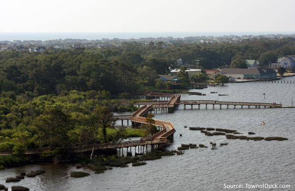
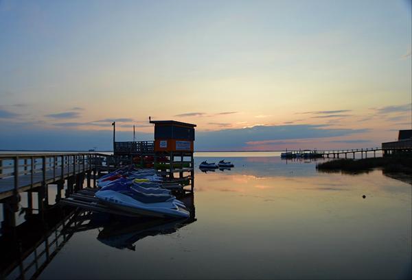
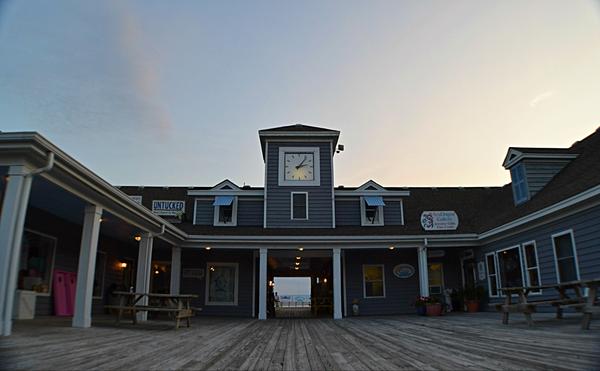
The Duck Waterfront Boardwalk

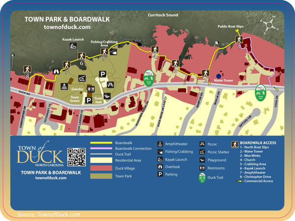
When you think of a ‘boardwalk,’ Atlantic City, Virginia Beach, & Myrtle Beach all come to mind. But did you know Duck, NC has a 4,149 square foot Sound Side boardwalk, spanning from Aqua Restaurant and Spa all the way to the Duck Waterfront Shops. There is even a Kitty Hawk Kites location on the boardwalk where you get discounts as a Stan White guest!

The Duck Town Park is a premier community recreational facility featuring 11 acres of natural beauty including trails through the Maritime Forest and willow swamp, open green space, soundside views, and access to the Town’s boardwalk.

Waterfront Shops:

Park Amenities:

  • soundside boardwalk
  • amphitheater
  • public kayak/canoe launch
  • four-slip, transient use boat pier at the northern end of the boardwalk
  • picnic shelter
  • playground
  • gazebo
  • water fountains, including a special one for our canine friends
  • walking trails throughout the park
  • summer events for everyone to enjoy annual Jazz Festival on the Sunday of Columbus Day weekend

Video Source: TownofDuck.com

*Original Photography unless source given

©2017 Stan White Realty & Construction. All Rights Reserved.

Website Design by InterCoastal Net Designs